Monday 30 January 2012

Port Lincoln and Lincoln National Park

As we said in a previous post, we changed plans for staying at Coffin Bay NP and ended up driving across the 40 Km at the bottom of the Eyre peninsula, to Port Lincoln. As we approached Port Lincoln from the west the first thing that struck us was the size of the place. Since leaving Ceduna we had not been to a large town for weeks. Port Lincoln has a population of 15,000 people. It nestles on the side of a massive bay that provides safe anchorage for large ships as well as a significant fishing fleet, tuna farms and oyster farms. Predictably, the fishing industry is a major employer in the town as well as being a centre for agricultural production.

Port Lincoln Beach Freshly Graded for the "Tunarama" Festival

The Grain Loading Wharf Dominates the Foreshore Vista
Looking out from the foreshore at Port Lincoln you cannot actually see where the entrance to the bay is as it is quite distant and obscured by islands. The town centre has a myriad of shops and business premises as well as a pretty foreshore and beach. The grain loading wharf dominates the waterfront but not in an ugly way as has happened with, say, the Port of Geraldton in WA.  The town is relatively hilly and many suburbs have commanding views over the bay.

Directly south of Port Lincoln is the Lincoln National park. Our aim was to spend a night at Port Lincoln and then find a spot at the NP and spend five or six days there. The only caravan park in town (there was another some distance up the east coast at North Shields) was perched on the side of a hill and many of the van sites had been carefully carved out of the hill to maximise the views. We were allocated a site in a drive-thru area of the park where all of the bays were staggered so that each site had unobstructed views of the bay. The sites were perfectly level and had concrete slabs for the van and annex to sit on. The "garden" was a few shrubs planted in the midst of a layer of crushed brick material. It was the most expensive park that we have stayed at so far, at $33.00 per night. Once we had set up the van we went for a quick sight-seeing trip and took a few photos.

Next morning we drove the twenty kilometres to the Lincoln NP. This NP has many different camping grounds to choose from, each offering something a little bit different from the others. Those who like a surfing beach should camp at September Beach. The camping area has had a lot of work done to ensure that visitors have nice level sites, long drop dunnies, walkways and bush walks. Those who are after sheltered sites can choose from Surfleet Cove, Horse Rock, Fisherman's Point, and Richardson's Hut sites. Surfleet Cove is bitumen all the way but the others mentioned are gravel roads access. All of these are accessible with a caravan in tow but those pulling non-offroad vans need to lift the right foot and go slow over the few sections of corrugations. The remaining campgrounds are more suited to people camping in tents or pulling off-road camper trailers. These include Taylor's Landing and Memory Cove campsites, with the latter accessible only with a key obtainable from the Port Lincoln Visitor Centre. Only 50 people are allowed at Memory Cove on any given day.

The Van, Tucked Away in the Scrub at Fisherman's Point

Just One of the Many Boats that Passed Each Day

The View Straight Out in Front of the Van. Port Lincoln in the Distance.
We chose to stay at Fisherman's Point, at a site looking across the bay to Port Lincoln. We had excellent views of the sea and the passing boats as well as being surrounded but natural bush (and the birds that come with the trees and shrubs.) The only drawback (as we found later) was that the entire campsite was prone to dust when the wind blew up. Not helping this were the peanuts who insist driving around the campsites for a sticky beak without realising how much dust they were raising at the speed they were driving. After setting up camp we sat back and did what we have become pretty good at doing....relaxing. In fact we relaxed for three days before actually exploring the rest of the National Park.

The fishing at the National Park was pretty ordinary. I got a feed (several times) by going down to rocks directly below our campsite and fishing for Luderick. I haven't caught Luderick before and had to ask another visitor if he knew what they were (after having already throwing many back). These fish are usually weed eaters but I was catching them on small pieces of cockle. Unfortunately for them they are very good on the tooth. I had no luck with the Whiting or Herring. Our "neighbour" has been to the same place for twelve of the past fourteen years and was telling me that the place is usually teeming with Whiting but this year he has only caught five (in about three weeks.) He went on to say that "Last year we filled a fifty litre freezer with fillets and the year before we filled that freezer and the freezer in the caravan as well." And he wonders why there aren't any fish!

The beach next to the Point was shallow, calm and pristine white sand that went out about 30 metres to the weed line. It was sheltered from the prevailing winds every day that we were there but I didn't take the kayak out because access to the water was difficult, to say the least. I had the first proper swim of our trip at this beach (I was too busy dodging sharks at Ningaloo to really enjoy a swim.)

The Beach, 30 Seconds Walk From our Camp
We took a full day to explore the other places at the NP, including a walk up Stamford Hill to the memorial to Mathew Flinders. This walk included a nine hundred metre climb up the hill, a walk that wasn't too steep but did have a slippery gravel surface that meant that you needed to keep your wits about you. Our friend Tanya would probably jog up the bloody thing, but we settled for a walk. If you take the trouble to get there, the views from the top were worth the effort. From this vantage point one could see the entirety of the bay that is Port Lincoln, as well as the town of Port Lincoln itself. In the other direction you could see over to the rugged southern side of the park where the Southern Ocean crashes against the cliffs. One of the other places that will stick in our memory was the lookout at Wanna, also on the southern side of the NP. I'll let the photos do the explaining.....

Wanna

Wanna

Wanna
There is a cottage at Donnington Point that can be hired by the public. It is a restored cottage from the earliest days of white settlement and is perched high up on a hill with truly excellent views over the sheltered side of the National Park's beaches. As Sue said, "It would be great to hire this cottage in Winter, light a big fire, sit in front of it and read books."

As good as the NP is, the continual swirling dust was starting to wear us down and after six days we moved on. This time we were starting the eastern half of the Peninsula, marking the halfway point of our exploration.

Some Musings

On Litter:


Unlike our home State of Western Australia, which is rapidly turning into a shit-pit, South Australia has very little litter on show. Contributing to this is the 10 cents per container refund on beverage containers, the very strong emphasis on recycling (even in the smallest of towns) and the fact that if you don't have your own bags at supermarket checkouts, you have to buy plastic bags at a price that must be a deterrent. (We don't actually know what that price is because we always took bags with us.)


On Wind:


You expect wind anywhere on the coast and the Eyre Pensinsula is no exception. Fortunately, the wind has only caused us to alter our plans on one occasion...right now as it happens...that's why I'm sitting here doing this Blog instead of fishing or sightseeing. The strong winds are not ideal for kayaking, especially on the east side of the Peninsula, where the seas are less protected, so if you plan to visit and are into fishing you would be well advised to bring a dinghy, or at least hire one. During the summer months the predominate wind is offshore on the west side of the Peninsula and onshore on the east side.


On the Towns:


The four key towns, Ceduna, Port Lincoln, Whyalla and Port Augusta, have most of the shops and services that you are likely to need on a holiday here. Outside of those towns the smaller places generally have a population of two to three hundred and the shops and services to suit. We have found the people in the smaller places are friendly and very helpful when pointing out the tourism highlights of their region.We always try to spend some money at each place we visit. It is fairly evident that the realisation has hit home that the farming and fishing industries will not be enough to sustain these towns into the future and that they need to do something to attract and retain tourists. Elliston, for instance, holds a Salmon fishing competition that runs over a three-month period during the winter months. This helps spread the tourist dollar over times outside of school holidays. Let's hope they don't shrivel up and die like so many other small towns in Australia.


On Drinking Water:


Many of the places we have stayed have no water at all. Many have bore water that is absolutely unfit for drinking. Of the rest (so far) that are on scheme water, the water is allegedly potable (drinkable), but by crikey it tastes like shit. If you tour the Peninsula, bring your own water - or a method of filtering some.


On the Roads:

The Flinders and Lincoln Highways (the two roads that flank the Peninsula) are excellent roads, with no significant inclines that would make towing a struggle. They are in a good state of repair and have plenty of long, straight, stretches for overtaking. The gravel roads, both major and minor, are well-made gravel or limestone surfaces that have enabled us to travel comfortably at 60 KPH while towing the van. Most of the roads are just short hops from the main highway to the attraction that you are visiting. We can say, after having travelled much of this country, that the roads here on the Eyre Peninsula are as good as you'll find anywhere, if not better.

On Free or Cheap Camping:

There are some excellent free or cheap campsites on the Peninsula. They are close together and you wouldn't usually need to travel for more than an hour between sites. The complication comes in if you can't carry a lot of water. Often the only reason you would leave a site is to get more water. Quite a few of the camp sites are close to the water, but few are right on the water's edge. National Park sites are generally well back from the water and have limited or tricky access (particularly for launching and retrieving boats or kayaks.) There are some absolutely stunning locations for free and cheap camping such as Sheringa Beach, Port Lincoln National park and Lipson Cove (the last two of which will be reviewed in upcoming blogs.) We have come to the realisation that we won't be able to visit them all and that the east side is more difficult when hoping to fish from the kayak. Summer school holidays means lots of visitors at these sites, so in some places you may miss out. We have been lucky enough to get in everywhere that we have tried.

On Caravan Parks:


Caravan parks are a necessary evil - if for no other reason than to top up water tanks or get a bit of washing done. All of the parks that we have visited have been adequate. I won't go into reviewing individual parks as the needs of each visitor is different. We have everything in our van and thus have little need for any of the facilities at a park. Others use just about all of the facilities. None of the parks we visited were of "Big 4" standard, but neither were they crapholes. Some places had more than one park to choose from and our criterion for choosing may differ from why other people would choose to stay at a place. Prices have ranged from $24.00 per night to $33.00 per night, with the average being $28.00 per night. One thing we have realised is that the more time you spend bush camping, the harder it is to get used to having "neighbours" at a caravan park.

Saturday 28 January 2012

Elliston to Coffin Bay


Sorry folks, Blogspot have yet again cocked up my ability to upload photos to the Blog. If I wait any longer I will forget what we have done, so, for the time being it will be words only.

Having topped up the water tanks and washed some clothes, it was time to move on from Elliston. We were keen to do a bit of bush camping and get away from the caravan park lifestyle for a while. The aim was to stay at the National park at Coffin Bay. Earlier in the trip we had purchased a Parks Pass that entitled us to enter and camp at National Parks in South Australia for a two-month period. The pass cost just $65.00 and we were keen to put it to some use.

Just 38 Km down the track from Elliston we turned of to Sheringa Beach. This beach offers cheap camping with a permit obtainable at the Sheringa Roadhouse (which is located on the Flinders Highway about 100 metres from the turnoff to the beach. Like all of the well-made gravel/limestone roads we have used in SA, this one was in good condition and would be accessible by standard two-wheel drive vehicles and non-offroad caravans.

The campsites are basically of two types. The first type is the formal camp area at the south end of the camping areas. This has reasonably delineated camping areas and there are two long-drop thunderboxes nearby. Beach access is via a sandy track that goes a short distance through the coastal dunes. Like many of these places, you must carry out all of the rubbish that you create. There are no rubbish bins and there was no water. Bring your own.

The second camping style is a series of individual nooks along the cliff face to the north of the beach. These afford the camper some quite spectacular views of rugged, rocky, coastline. There is wooden stairway access to a couple of very small coves along this section. The coves appeared to be safe enough to swim at, provided one studied the wave pattern for a while first, just to be sure no big breakers roll in unannounced.

We were tempted to stop at Sheringa but the day we were there it was particularly windy and the campsites were very exposed to the wind in the direction from which it was blowing - so it was a case of sticking with Plan A. I guess it is a symptom of our being "beached out" that we didn't even take a photograph of Sheringa Beach.

The Flinders Highway had so far taken us through a lot of farming country with mostly coastal vegetation that tends not to be overly green, nor very tall. The further south we progressed, the evidence of more rain was in the height and size of the trees. We began to see many eucalyptus species that were as high as 30 metres. There were even some freshwater lakes (as opposed to the predominance of salt lakes that we had seen up until now.) This reminds me of something that I haven't mentioned previously......

We have seen a lot of waterfowl (ducks, geese, swans) that you would usually see paddling around on freshwater sources, bobbing around in the sheltered bays of the Eyre Peninsula coastline. I have not experienced seeing these particular waterbirds inhabiting saltwater environments, until now. One can only guess that the farming has caused most of the inland lakes to either dry up completely, or turn into salt lakes - forcing the waterfowl to adapt. And adapt, they have!

Anyway, back to the story. Within an hour we had reached the turnoff to Coffin Bay, leaving us just 17 Km to the townsite. As you drive into Coffin Bay you immediately see just how protected the waters are. The area is also reasonably hilly, enabling people to build houses on the slopes and take advantage of the views. The other impression is the amount of trees in the area. You go for long periods of time travelling this peninsula without seeing substantial tree growth, and this reawakens you to their presence.

Panorama shot from lookout at Coffin Bay
We drove through the town of Coffin Bay and made our way to the National Park. The plan was to set up camp there and use it as a base to explore everything in the area. The road to the campsites was bitumised but very windy and narrow in places. It took us at least half an hour to cover the 20 Kilometre distance. When we arrived there were two signs. One was a symbol of a caravan and pointed to the left and the other was a symbol of a tent and pointed to the right.

The problem was that the water was to the right, at least 200 metres from where the caravans were supposed to park. This would mean a fair old trundle to the water with the kayak, made worse by the fact that it would be all uphill on the way back! The second problem was that the campground for caravans was nothing more than a dustbowl that had been denuded of any trees. There was no shade to peak of and the dust was blowing everywhere in the wind.

We parked up and took a walk down to the water's edge to find that the small cove was very shallow, obviously didn't get much flushing by currents and was lined with stinky mud instead of beach. On the walk back we went for a look around the tent camping area and saw that these had been well set up with nicely defined bays set amongst some well established trees for shade. We could possibly have got the caravan in there (and while we were there, another caravan did sneak in) but we didn't want to break any rules.

Our jobs at Cossack require us to enforce the camping guidelines of the Shire of Roebourne and it would be hypocritical of us to be enforcers at home and transgressors while away. National Parks, a message for you.... The area set aside for caravans at Coffin Bay is a disgrace. Why should tourists in caravans be treated any differently to people in tents or camper-trailers? We pay the same entry fees! Lift your game (and expect a formal complaint from us as well.)

Jetties and foreshore at Coffin Bay
So we decide not to stay at Coffin Bay. There were other campsites but these required driving through very deep sand - no problem if you aren't pulling a 3.5 tonne caravan behind you. There was also a caravan park at Coffin Bay but we figured that because we needed to pick up some supplies at Port Lincoln, we may as well stay at the caravan park there.

Off we trundled for another 40 or so kilometres to Port Lincoln. We set ourselves up in the caravan park and had a quick look around, before calling it a day and returning to the van to dream up Plan B. Plan B is the topic of the next blog. See ya.


Tuesday 24 January 2012

Road Sign

Hi Folks

This is just a little novelty that we have spotted in our travels. These signs are seen a lot on the major routes around SA. They're certainly not mincing their words symbolism.


Monday 23 January 2012

Venus Bay to Elliston

Not far from Venus Bay, on the way south, are the Talia Caves.

Location of Road into Talia Caves

We called in there and had a look. It was a grey day so the photos don't do the "caves" justice. These aren't caves in the traditional sense. They are simply where the action of the ocean has eroded the limestone where it is softer, making hollows where it occurred. I was actually more attracted to the shapes that the rocks had formed and the layers of different colours than I was to the caves.

Staircase leading to "Woolshed" Cave"

The first cave that you get to is "Woolshed" Cave. I think that it is named solely because of its size. It doesn't have any other similarities to a woolshed.

Woolshed Cave
The rocks around the Woolshed Cave have eroded into channels which funnel the water into the cave during storms. It is expected that the cave will continue to erode and that the roof will eventually collapse.

One of the natural channels that funnel water into the Woolshed Cave
Crikey! I actually thought I'd lost weight - until I saw this photo.

From Woolshed Cave it is a short drive to the next easily accessible cave, "The Tub". This cave is the result of the action of the sea carving into the limestone, forming a very large cavernous space with a relatively small entrance. The roof of the cave collapsed and the rocks that fell were washed out of the cave, leaving a large, tub-like, hole in the ground.

Part of The Tub. The entrance is just out of view at the front-right.

The view from the other end of The Tub, showing where the water enters.
There are many caves at Talia but to access them requires a walk along the waterline - definitely best done at low tide and with a calm sea. We had neither and deemed it an unnecessary risk to go and view them. We did drive to where the rocky coastline meets the beach and were rewarded with views of yet another pristine piece of coastline. Those of you who have toured the Kimberley or Central Australia will be familiar with the term "Gorged Out" - where all of the gorges are spectacular, but they start to get a bit "ho hum" - well, on the Eyre Peninsula you can get "Beached Out" in much the same manner.

Where the rocks become beach at Talia
Moving on from Talia caves we came across a sign on the side of the road that said "Colton Bakery - OPEN", yet there was no bakery, just an old house in the trees. We had been told about this place by many travellers that we had met since arriving in SA. A closer inspection revealed a little "cubby" on the side of the road, near the house. It had a sign that said "Fresh bread from a wood fired oven". In the cubby was a sliding window and once opened there were shelves of fresh baked bread and rolls. None of the loaves was sliced and they were the old style loaves like Cob loaves, Tank loaves, Twist loaves and Upright loaves. The loaves were $3.50 each, regardless of whether they were wholemeal, multigrain, white, or what shaped loaf they were. I have to admit, it was the beautiful  smell of fresh bread that won me over. We came away with a white Tank and two multigrain Cobs.You leave your money in a tin inside the cubby. It is an honour system and I guess it works or the baker wouldn't bother continuing.

So there we were, driving down the road toward Elliston with the smell of fresh, wood fired, bread permeating throughout the car. Talk about torture! Just before Elliston there is a clifftop drive. As usual, the scenery was exquisite, but this drive had something else as a drawcard. Along the drive were placed sculptures made of different materials. All were interesting, some were downright clever and others amusing.

One of the sculpture on the clifftop drive near Elliston.
More sensational Eyre Peninsula coastline.
The drive is quite short, probably less than 10 kilometres in total, but worth doing. From there it is just a few minutes to Elliston.

Location of Elliston

Elliston has a population of around 350 people. Like most of these coastal communities it is located on the shores of a sheltered bay, but in Elliston's case, not quite as sheltered as places like Venus Bay or Streaky Bay. The town has two caravan parks which gives you the idea that tourism is one of the major industries. There is a small supermarket, a couple of servos, a Community Hall and a smattering of small shops - along with the mandatory jetty. We didn't take any photos at Elliston because, sadly, nothing really jumped out at us and said "Take Me!" I did take a shot of our site at the caravan park, complete with the towering grain silos.

Look! Grass! We didn't even set the table and chairs up because it was too darn cold outside.
The only reason that we stayed at Elliston was that we needed to fill the caravan water tanks. The water at Venus Bay was unsuitable and my 12 Volt pump had shit the tin, making it impossible to filter any water there. From Elliston the intention was to bush camp at the National Park at Coffin Bay, thus we needed to take as much water as possible as none would be available at the NP....but that's another story. Stay tuned.

Friday 20 January 2012

More Venus Bay

10 days at Venus Bay have gone by very quickly and it was soon time to move on. But before I post a blog about the next stage of our travels, just some information about Venus Bay for those who may be interested in visiting....

The two main forms of accommodation at Venus Bay are private holiday cottages and the caravan park. To get a holiday cottage during peak times (school holidays) would require you to book many years ahead of when you actually wish to go, or kill someone who has already got a regular booking. Most of the rentals, where handled by an agent, appear to be handled by the estate agents at Streaky Bay. Many of the remainder just have a sign out the front with telephone number on it, which means that you actually need to go there first in order to gather some of these numbers.

The caravan park also takes bookings years in advance. We have booked a place for 2014 while we are here. The park is not huge, having around 65 sites and 10 cabins, and by the time you take out the sites that are booked on an annual basis there are not many available for the casual visitors (in peak season anyway.) So, you would be well advised to book. The Hosts, Linda and Chris Smith, are lovely people who are only too happy to help you.

The Caravan Park Shop

As posted previously, the water quality is poor. You wouldn't drink it and we were advised not to let it get into the hot water service in our van - which basically meant not using it at all. I would advise carrying in as much water as you can, or have some very good filters. You can buy drinking water there but it would get pretty expensive over a long stay. The water is good enough to shower and wash clothes in. There are a couple of rainwater tanks and the sign near the tap implores you take just two litres at a time so that there is enough to go around - something that seemed to elude a chap I saw filling a 20 litre drum.

Site fees range from $23.00 per night for unpowered to $25.00 per night for powered, based on two people staying. Extra persons are $6.00 per night each. Cabins range from $45.00 per night to $115.00 per night. 24 of the caravan/tent sites have absolute beach frontage or unobstructed views, as do three of the cabins.

There are two amenities blocks, two camp kitchens and two fish cleaning stations. The laundry has three washing machines and one dryer and washing costs $3.00 per load.

When cleaning fish, you will have a guaranteed audience.

The park shop, as mentioned in a previous blog, has a kitchen and serves the usual take-away food at very reasonable prices -$14.50 for fish, calamari and prawns, served with chips, is the most expensive item on the menu. You can sit on the balcony of the shop while eating your food and enjoy some excellent views over the Bay.

You can hire boats at the park shop for just $15.00 per hour with a minimum 3 hour hire. They include all of the safety gear required by  law and Chris, the host, will surely give you some tips about where to go to get "onto" the Whiting.

Hire a boat (or bring your own) and join the dozens of others that go out each day.

A  note about security. This would have to be one of the last remaining places in Australia where you can go away from your van and leave everything where it is, then expect it to be there when you return. When you stroll around the park you see fishing gear lying around everywhere, dinghies left on the beach with motors attached, fuel tanks in them, all the safety gear and most likely the fishing tackle - all sitting there unattended. People don't lock their vans when they go fishing and many don't bother locking their cars either. Neighbourhood watch would stop any wrongdoers, even if there were any, (which is very unlikely.)

Summary


If you like your caravan park to be basic but clean and tidy, if you like fishing, if you like feeling totally safe and secure, if you enjoy nature, if you don't mind a banter with people whom are total strangers when you arrive (but not by the time you leave), if you're into photography or videography, if  25 to 33 degree days and 14 to 18 degree nights are right for you, if you don't mind a bit of wind (it is on the coast, all said and done), if you don't mind being a half hour drive from a real supermarket, then this is the place for you. If you want to go a little more up-market, try hiring a holiday cottage. This is the holiday town that we all grew up going to. The town that has disappeared from most of Australia, but is still alive and well at Venus Bay. Uncomplicated life still exists.


I rate Venus Bay at 9/10


Sunday 15 January 2012

Venus Bay

Venus Bay Location

We arrived at Venus Bay and booked into the caravan park for two nights. By the time we had finished setting up the van and been for a quick walk around we had decided to extend that to a week. By the time we were halfway through that week we had extended for another three days, making it the longest time we have stayed at any place so far.

Venus Bay town is located on the shores at the southern end of Venus Bay, the bay.


The town is small and exists mainly for tourism. The bay itself, as stated in the previous blog, is more like a lagoon. It has a narrow opening and then widens considerably.

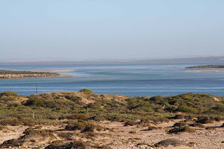
The opening to the sea is actually the bit to the left. Everything to the right is the bay.

There is a big, sandy, island straight out from the town and we intend to paddle across in the kayak and have a picnic lunch over there (probably tomorrow.)  To get there we will have to paddle over three separate, narrow, very fast flowing channels between the sand shoals. This will require us to aim quite a bit to the right of the island in order to make landfall on the island.

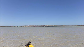
We did get there! Taken from the beached kayak over at the Island.

There is a jetty here and this is one of the places where the pilchard boats bring their catches so that we West Australians have mullies for bait.


A pilchard boat came in on the third day that we were here and disgorged almost 50 tonnes of pilchards. Watching the boat unload its catch was very interesting - they literally pump the fish out of the hold into tanks on wheels that are hand-pushed along rail tracks on the jetty, to an awaiting truck.


Naturally, quite a few of the fish spill out during the various stages of the process and these are swooped on by the throng of people who have gathered on the jetty to watch the event. Any that fall in the water are grabbed by seabirds. A huge slick of fish bits, blood and scales forms down the tide from the pilchard boat and some of the fishos anchor their boats in the middle of it, trying to catch the fish that are attracted by the bonus food.

Aside from the fishing fleet (three trawlers have been tied to the jetty since we have been here) there appears to be little else to sustain the town.The general store is also a cafe/restaurant, fuel station and liquor shop and the caravan park also has a small selection of general merchandise and serves food.

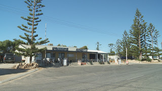
The General Store/Liquor Shop/Cafe/Servo

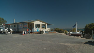
The Caravan Park Shop/Cafe

There is no school, no hospital or Doctor's surgery, no Police Station and no Government agencies of any sort here.

The town water supply is from bores and is not fit for drinking, so the houses all have rainwater tanks. The shops both sell 10 litre boxes of water and have them stacked high on the floor. At least they have mains power.

Our site at the caravan park is in the front row, with nothing between us and the sea shore (apart from a couple of small wheelie bins). We have enough room to drive the van in forwards, unhitch the car and move it forward and still have enough room for passers-by to walk in front of the car. We have put the solid annex end piece on to create a wind break and have also put up one of the side screen for the same reason. This creates a nice roomy, sheltered area to sit in outside of the van.

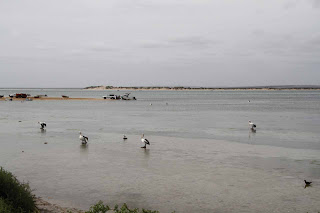
The view straight out in front of our van.

From our vantage point we can watch the coming and goings of all of the dinghies that put to sea, trying to catch their quota of King George Whiting. On day two I took the kayak out and, following some advice given to me by our next door neighbour, proceeded to the edge of one of the channels to drop a line. After an hour or so of nothing much happening I decided to move to some ground that looked similar to where I'd caught whiting at Smokey Bay.

The move paid off immediately and I finished up with ten KGW and a solitary Herring. You've got to be happy with that! Must have been beginner's luck because the next two outings resulted in just one fish each time.

The scenery here is quite spectacular. If you walk from the edge of the water on the bay, up the hill through the town to the top, you find yourself overlooking the open ocean. This side is lined with limestone cliffs, still part of the Great Australian Bight, that have been etched out of the land by the constant pounding of the sea.


From this high-point you also get an idea of just how big the bay is and the deeper, dark coloured channels stand out against the turquoise of the shallower, sandy bottom. Indeed, this place is just made for aquatic pursuits.

The weather Gods have been kind to us and we have had only one very brief rain shower since we arrived. The temperatures have been in the mid-twenties during the day and high teens at night. We are expecting a 34 degree day tomorrow, before the weather cools again. Like most coastal areas, it is pretty windy here. Thankfully the high cliffs on the other side of town offer considerable shelter for the bay, so that even though the wind is strong, the seas are relatively calm.

More about Venus Bay in the next blog.


Thursday 12 January 2012

Streaky Bay to Venus Bay

It was a shame that we had to leave Streaky Bay before seeing it in good weather conditions, but with so many places to visit on the Eyre Peninsula, we had to keep moving. As stated in the previous post, we weren't all that enamoured with the place anyway. So it was that we packed up and headed off at around 10:00 in the morning on Monday the 9th January.

We only wanted to travel a hundred kilometres, at most, which would see us get no further than Venus Bay. Between Streaky Bay and Venus Bay are Baird Bay and Port Kenny. We turned off into Baird Bay and found ourselves on a well-made gravel road. This has been a feature of our travels around the Eyre Peninsula - well-made gravel roads that have been recently graded. This means that we don't have to stop to reduce the pressures in our tyres to prevent everything from shaking to pieces. Letting down the tyres isn't an issue. Pumping them up again is. It takes a long while to pump up eight 4WD sized tyres.

The road to Baird Bay cuts through cleared farmland. A great many of the farmhouses in the area have fallen into disrepair - a sign of the hard times. Much of the land does not appear to have been cropped for a few years and we did not see a single farm animal. It leads one to think that some of the farms have been abandoned. Folks, if you still don't believe in climate change you need to come to a place like this and see what is happening.

Baird Bay Location

Baird Bay is a very small settlement on the shores of a very large, very shallow, sandy bay. The town doesn't have as much as a shop, just a few houses. The locals have made a cheap campsite for tourists which is located about 70 metres from the water's edge on the "land" side of the road that comes into the settlement. It is basically a gravelled clearing with a small "camp kitchen" styled building and some toilets. The camp kitchen has a gas BBQ and a sink for doing dishes. The locals ask for a gold coin donation to use the BBQ, but there really isn't any way of stopping unscrupulous people from using it for free. To stay at the camp site costs $10.00 per night.

The campground, camp kitchen and village at Baird Bay

The day-use only car park, fish cleaning station and "rubbish tip"

Part of the Bay


At one end of the campground are some stairs that lead up to a lookout. It is not a very high vantage point, but high enough to get some nice views and take some piccies like those included in this blog. On the other side of the road from the campground is a day-use only parking area that is much closer to the beach. The path from this car park to the beach takes you right past a fish cleaning station. These are everywhere in this part of Australia and are a welcome addition. The Baird Bay rubbish tip is also parked at the end of this car park. That's right, parked! The local rubbish "tip" is a tandem trailer with a mesh cage on it. I guess they just tow it to the main tip (wherever that is) when the trailer is full.

Happy as we would have been to camp at Baird Bay, we decided to have a cuppa and then drive on. We saw a road that was signposted "Murpy's Haystacks" and as it took us in the general direction that we wished to go, we took the turn. After a short drive we got to the haystacks.

Murphy's Haystacks Location

You can't really see them from the main road, so I guess that quite few people would drive right past them. The "haystacks" are actually large rock formations, some of which rest on the ground and some that rise up from the ground. What makes them unique is that they a re a form of conglomerate that is different in texture, make-up and colour from the surrounding limestone country. They have been smoothened over the years and have taken on some odd forms which are quite appealing to view. I think that words alone cannot do them justice and have included the photos to give a better idea of how they look.


The story goes that an Irishman named Murphy, who had a penchant for a particular method of farming, was known to constantly espouse how his style of farming could produce far greater yields of hay than traditional methods. One day, when taking a party of farmers on a wagon to a distant farm so that he could demonstrate his techniques, he saw the rock formations in the distance and thought that they were giant stacks of hay. He then theorised that the farmer that grew enough hay to make stacks as large as those "must surely be using my farming methods".

Subsequent travellers along the trail saw the folly of Murphy's "haystacks" but the name stuck and they have been known a Murphy's Haystacks ever since. The formation is on private land and they ask a donation in an honour box to enter. They money seems to have been spent well as there are some very clean, flushing dunnies there, in the middle of a paddock with not another building in sight.

From the haystacks, the road back to the Flinders Highway is bitumen and before long we had turned southeast and were heading for Port Kenny.

Port Kenny Location

It didn't take long to reach Port Kenny. Port Kenny is another small village on the shores of the quite expansive, Venus Bay. This bay is so large that Port Kenny is probably about 12 kilometres from the open sea. The bay is actually more of a lagoon that has an entrance to the sea that is about 500 metres wide, then  opens out and I'd guess it covers a hundred square kilometres or so. Port Kenny would be a port for fishing vessels only, as it is too shallow for anything else to navigate.

Port Kenny is also a bit, shall we say, bedraggled. The place has junk left over from a bygone era spread all over the place. Things like old boats and old aquaculture tanks, along with old rope, nets, cars and a host of other flotsam and jetsam are dotted everywhere. The town has a pub and a roadhouse and maybe 30 houses. The roadhouse had some caravan sites but I'm being generous by calling them "primitive". So it was on to Venus Bay Township.

Venus Bay Location

On arrival at Venus Bay you find yourself at the entrance to the large bay that I spoke of in the earlier paragraph. The town is also smallish, possibly with 70 permanent residents, but has a lot of holiday housing that would see the town population get up into the hundreds during holiday times. There is the mandatory pier, a General Store which also doubles as a cafe and triples as a liquor shop, a caravan park and the houses mentioned previously. I will cover Venus Bay in a separate blog.

Streaky Bay

Sorry about the delay updating the blog - blogger.com have had an issue that prevented the uploading of photos. I have had the words typed up for days, waiting for them to fix the problem.

Streaky Bay Locality Map

Sue and I like to think that we are experienced travellers and experienced travellers go to great lengths to not let the weather at a place influence their opinion of that place, especially bad weather. And so it was with Streaky Bay that we had to try very hard not to think negative thoughts as we huddled out of the fierce winds and the rain squalls.

We did manage to fit in a 14 Km round trip on the bicycles before the rain set in. We rode from the caravan park, almost to the boat ramp (more about that later) and back and then into the town centre and back. It is probable that Streaky is a pretty place, but with grey skies making the ocean seem grey as well, it was difficult at times to even make out the horizon. The water looked rather unappealing.

We stopped at this shelter on the way back from our ride "almost" to the boat ramp.
The town itself it the largest we have been to since we left Ceduna and would be less than an hour's drive from Smoky Bay if we didn't deviate off on side-trips. It has a couple of supermarkets (both of which practice robbery without violence), a couple of servos, a pub, a smattering of restaurants, a hardware store, a rural merchandise store and a few smaller shops. It is quite hilly and some pretty impressive houses have been built on the hills to take advantage of the ocean views. Many historic building are scattered throughout the town.

Streaky Bay viewed from the shelter in the photo above.
Part of the Streaky Bay foreshore, viewed from the pier.
Streaky also has a couple of imposing grain silos and the mandatory jetty (or pier). In Streaky the jetty is a focal point for the hospitality industry with several restaurants and the pub all located to maximise their views of it. The jetty also has an area about 2/3 the size of an Olympic pool attached to one side of it and this area is enclosed in mesh so that people can swim there without becoming White Pointer fodder. A 1500 Kg White Pointer was caught off Streaky Bay in 1990, so you see why people get a bit jittery about them.

You can see the shark cage on the right hand side of the Streaky Bay pier.
Streaky Bay also has the unfailing knack of having cycle paths that end abruptly in the middle of nowhere (hence the almost getting to the boat ramp that was mentioned previously.) We managed to find the ends of several of them.

I'm told by several people at the caravan park, that the fishing is good at Streaky Bay, but no-one went out during the two days that we were there due to the bad weather. The caravan park is the largest that we have stayed at since we got to SA. Our site was one row back from the beach. The beachside sites attract a premium price and you have to wait for someone to die before you can get onto one - not surprising, due to the Christmas school holidays. Our site was $28.00 per night. The regulars reckon it's getting pricey, but having come from the north, it is bloody cheap by comparison!

Our site at the caravan park. Note the grass in the foreground!
Also due to it being school holidays there were a couple of hundred kids running amok the whole time we were there. Now I know why we like bush camping so much. There are a couple of scenic drives not far from Streaky. One goes out to Point Labatt, where there is a seal colony and the other goes out around Cape Bauer. We took the latter but the rain got so bad that we couldn't see much. The bits that we were able to see were quite spectacular.

In summary, Streaky Bay is definitely more up-market tourist oriented than the other places that we have visited prior. It is not our cup of tea but I can see why it would appeal to some people. The van park was neat (and even had grass), busy, and full of mostly unsupervised, rowdy kids. The shops are basic and expensive, but the hospitality side of things has plenty on offer.  I give it a 6/10 rating.